


Ste Geneviève

bouscaillou
User
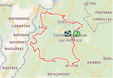

Length
25 km

Max alt
898 m

Uphill gradient
665 m
Km-Effort
34 km

Min alt
679 m

Downhill gradient
665 m
Boucle
Yes
Creation date :
2022-05-11 07:20:24.839
Updated on :
2022-05-11 15:43:32.802
8h22
Difficulty : Very difficult

FREE GPS app for hiking
 SityTrail
IGN / Geographical institutes
SityTrail Plus
The world is yours!
About
Trail Walking of 25 km to be discovered at Occitania, Aveyron, Argences en Aubrac. This trail is proposed by bouscaillou.
Photos

Positioning
Country:
France
Region :
Occitania
Department/Province :
Aveyron
Municipality :
Argences en Aubrac
Location:
Unknown
Start:(Dec)
Start:(UTM)
481037 ; 4960855 (31T) N.
Comments